
| |
AVI 080 Project "ACROSS" |
"Analyzed Climatology of Rainfall Obtained from Satellite and Surface data
for the Mediterranean Basin"
by M.C. Todd and E.C. Barrett
The ACROSS Project aims to produce a unified satellite and raingauge climatology of rainfall over the Eastern Mediterranean region, in order to permit a more satisfactorily evaluation and interpretation of over land and over water rainfall anomalies than has been hitherto possible, and to consider major effects of significant rainfall anomalies through related analyses of passive microwave data on land surface types.
A central component of this work is the processing of satellite data to produce rainfall estimates. This Progress Report describes the satellite sensors used and the work carried out in the Centre for Remote Sensing (CRS) University of Bristol during the first six months of the Project in acquiring and preparation of imagery to enable the production of rainfall estimates from these data.
The Scanning Multichannel Microwave Radiometer (SMMR)
This instrument operated briefly on the SeaSat mission in 1979, and
on the Nimbus-7 polar orbiting meteorological satellite which was in operation
between 1978 and 1987. The Nimbus-7 SMMR, described by Gloersen and Hardis
(1978) and Gloersen and Barath (1977), provided all of the SMMR data used
in this study.
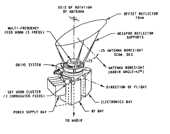
The Nimbus-7 satellite had an orbiting period of 104 minutes, and crossed
the equator at noon and midnight local time. The receiver consisted of
a multifrequency feedhorn at the focus of a reflector which rotated about
an axis at 42° to the vertical. The curvature of the Earth resulted
in an angle of incidence at the Earth's surface of 50°. The oscillation
of the reflector results in a curved scan line being swept out covering
822 km on the Earth's surface, with observations covering 780 km (Gloersen
et al., 1984).
Five frequencies (6.6. 10.7, 18, 21, 37 GHz) were sampled in both horizontal
and vertical polarisations resulting in ten channels of data. The two polarisations
are scanned alternately by four radiometers for the four lower frequencies
while for the 37 GHz channel each polarisation is measured simultaneously
by a separate radiometer. The dwell times of all the channels are integral
multiples of, and synchronous, with the 37 GHz channel dwell time of 32
ms. A subsatellite velocity of 6.5 kms-1 and scan period of
4.096 seconds mean that overlap coverage was achieved at all frequencies.
The configuration of the instrument is shown in Figure 2.1.
The raw radiometric readings were corrected for actual antenna patterns including sidelobe effects, and the vertical and horizontal polarisation components of the brightness temperature were separated out. The degree of polarisation mixing was greatest towards the edges of the scan because the oscillating reflector fed a fixed receiving horn causing the orthogonal polarisation components of the incoming radiation to rotate with respect to the polarisation axes of the SMMR (Gloersen et al., 1984).
Data from the SMMR were obtained by the CRS in the form of "Temperature Calibrated Tapes" (TCTs) for the entire instrument operation period from 25 October 1978 to 20 August 1987 from the US National Space Science Data Center (NSSDS) Greenbelt, Maryland.
The Special Sensor Microwave / Imager (SSM/I)
The SSM/I instruments are flown aboard members of the current series (Block 5D-Z) Defense Meteorological Satellite Program (DMSP) satellites. These satellites are polar orbiting with an inclination of 98.8° and a period of 102 minutes.
The first SSM/I instrument was launched in June 1987 aboard the DMSP-F8 satellite. Since then a further three SMM/Is instruments have been launched. Currently the SSM/I on board DMSP-F10 and F13 provide data for operational purposes. The F10 was launched into an elliptical orbit resulting in an advancing overpass time at the rate of 5 sday-1. The SSM/I on board DMSP-F11 experienced an early failure of one of its onboard tape recording facilities resulting in a loss of data coverage, primarily over the north west US. This should have little effect on the study region.
The SSM/I instrument consists of an offset (42° from vertical) parabolic reflector which spins about a vertical axis producing an angle of incidence of 53.1° on the Earth's surface. The active part of the scan covers ± 51.2° on either side of the sub-satellite track corresponding to nearly 1400 km on the Earth's surface. There are seven channels of data, covering four measurement frequencies of 19.35, 22.235, 37 and 85.5 GHz. Dual polarised measurements are made at each frequency apart from the 22.235 GHz channel which has vertical polarisation only.
The SSM/I differs from the SMMR in the following respects.
Data Processing
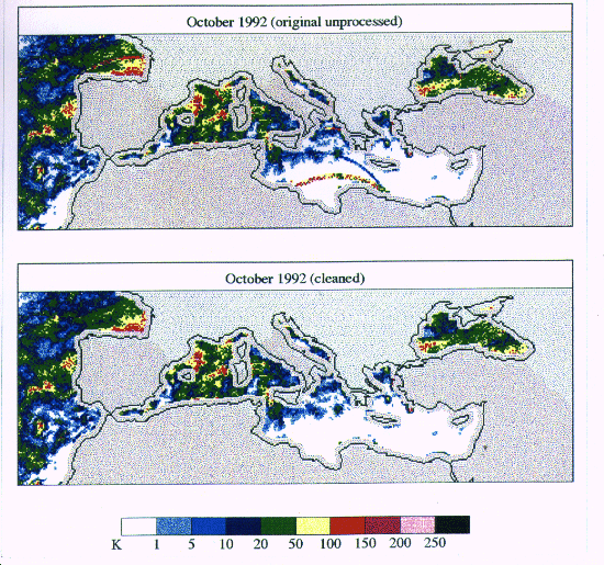
An example of a monthly rainfall estimate produced from SSM/I F8 data covering the study region is presented in Figure 3.1
Due to the great volume of data involved in ACROSS, including both SSM/I and SMMR, an automatic quality control procedure has been devised and incorporated into the data processing. For each month of SSM/I and SMMR data covering the study window statistics on the Tbs are obtained for each scan line. Plots of mean, maximum and minimum Tbs for a given channel are obtained. Data which lie outside a specific range either side of the mean, maximum and minimum Tb (in terms of standard deviation) are deemed “bad data” and are identified and the associated scan time numbers flagged. Subsequent display routines then mask out the bad data. An example of this procedure is shown in Figure 3.1, where corrupt scan lines leading to errors in rainfall estimates are removed by the cleaning procedure, without effecting the non-corrupted data.
![]()