
| |
AVI 080 Project "ACROSS" |
"Analyzed Climatology of Rainfall Obtained from Satellite and Surface data
for the Mediterranean Basin"
by L.G. Lanza
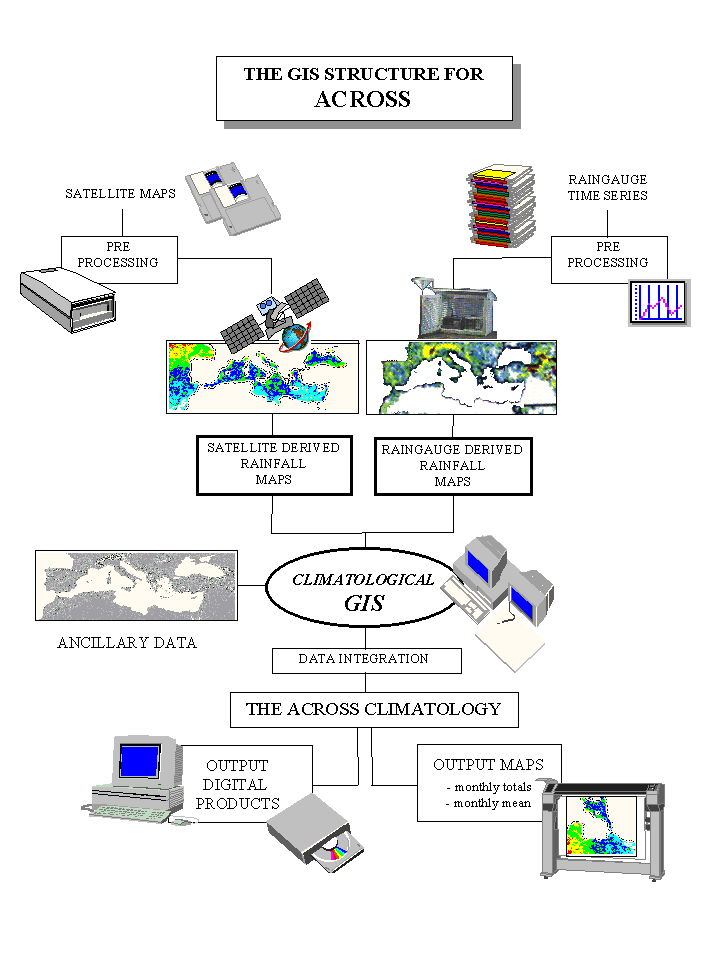
As already outlined under Task 1.4, the basis for the management of climatological data within the ACROSS project will be provided in the form of a GIS-supported archive of geographically referenced information. The structure of the archive was therefore designed accordingly, together with the formats of all datasets to be included and integrated with each other (mainly as far as the satellite-derived and ground-based categories are concerned). The information collected and produced as a result of the ACROSS project will also be integrated with ancillary data and other climatological and geomorphological information already available as being the output products of different international projects which have been operating over the same area.
The objective of Task 2.2 was the eventual development and implementation of a hydrological and climatological database system integrated within a "hydrologically oriented" Geographical Information System (GIS). Also, the development of automated procedures able to support the handling of data archived in the system - with specific reference to dedicated algorithms for optimization of the storing, georeferencing and integration of satellite products and ground-based hydrological data - was envisaged. As in many practical applications of hydrological studies, Geographical Information Systems are forced to deal with a large amount of data collected from different sources and usually scarcely comparable in terms of their spatial and temporal monitoring resolution. Suitable representation scales are furthermore introduced in the description of the natural system by our hydrological interpretation of the monitored parameters. Techniques for data aggregation and disaggregation able to transfer the acquired information to the different scales involved are still a field of current research among hydrologists.
In this report a sinthetic description is provided of the work undertaken during the first year of the project activity under Task 2.2, together with a synthetic documentation of the GIS tools developed and implemented. In section 2 the hardware and software characteristics of the system as a whole are described, with reference to the commercial packages used and their performances. In sections 3 the links of the GIS engine with the ACROSS database and the procedures to update the information stored - and thus the results of the elaboration - are described.
Session 4 is devoted to the description of the agreed geographical reference system for both the display of the project outputs and the data elaboration exercises. In sections 5 and 6 the data storage and display strategies for satellite derived and ground-based precipitation climatology products are reported in view of the eventual integration effort. The data integration capabilities, whichever is the numerical algorithm to be adopted for the calculations, are finally described in section 7.
![]()