U.S.-ITALY Research Workshop on the
Hydrometeorology, Impacts and Management of Extreme Flood
Perugia; Italy, Nov. 13-17, 1995
LEARNING FROM REMOTE SENSING FROM SPACE
Alberto MUGNAI
Istituto di Fisica dell'Atmosfera,
Consiglio Nazionale delle Ricerche,
Galilei, 00044 Frascati, Italy
Phone: +39-6-941.86215 - Fax: +39-6-941.86266;
This presentation examines the relative merits of precipitation estimation
from different types of satellite sensors and different satellite orbit
configurations, in terms of both current and future spacecraft technology.
At the outset, some of the basic physics and properties of modern space
sensors are reviewed, to help establish the basis for why we should proceed
simultaneously with precipitation retrieval in both the microwave and optical-infrared
spectrums. Examples of precipitation retrieval based on Special Sensor
Microwave/Imager (SSM/I) measurements and METEOSAT infrared measurements
for the Valtellina-1987, Genova-1992 (see Figure 1), and Piemonte- 1994
extreme flood events are presented to help place these concepts into an
application oriented framework. A brief overview is given of how an SSM/I
rain-profile retrieval algorithm developed at the Institute of Atmospheric
Physics in Frascati, Florida State University in Tallahassee, and the University
of Rome, based on a combined cloud-radiative transfer model, is being used
to develop the physical underpinnings for a transfer calibration procedure
which can be applied to lower fidelity rain retrievals from METEOSAT infrared
image sequences. The merits of this combined approach within the framework
of a mesoscale model-satellite rain prediction-monitoring system applied
to flood-producing mountain storms is addressed in the companion paper
by E.A. Smith, A. Mugnai, and G.J. Tripoli. A brief review is also presented
concerning the respective advantages and disadvantages of high inclination
and low inclination low-altitude spacecraft orbits versus high-altitude
geosynchronous spacecraft orbits, vis a vis the problem of rainfall monitoring.
This discussion considers: a), the sun-synchronous U.S. Defense Meteorological
Satellite Program (DMSP) satellites which carry the SSM/I passive microwave
instruments; b), the non-sun-synchronous NASA/NASDA Tropical Rainfall Measuring
Mission (TRMM) satellite (to be launched in late 1997) which will carry
a microwave radiometer, a visible-infrared imager, and a precipitation
radar, but will be in a limited coverage 35 degree inclination orbit; c),
the future polar platform MetOp of the European Space Agency (ESA), which
will probably carry the Multifrequency Imaging Microwave Radiometer (MIMR);
and d), ESA's Earth Explorer Mission on Precipitation, which is presently
under study. High resolution aircraft radiometer measurements from the
NASA Advanced Microwave Precipitation Radiometer (AMPR) and the Millimeter
Wave Imaging Radiometer (MIR) obtained in February, 1993 during the Tropical
Ocean Global Atmosphere - Coupled Ocean- Atmosphere Response Experiment
(TOGA-COARE), are used to demonstrate the inherent correlation (actually
anti-correlation) between precipitation features in the low and high microwave
frequency range. These results are used to advance arguments on why a high
frequency microwave radiometer mounted on a geostationary satellite, would
be a useful tool for monitoring precipitation, based on the rain signatures
emanating from upper levels within the cloud column. The presentation concludes
with remarks on why, given the current spacecraft technology, it is important
to combine optical-infrared spectrum measurements from geosynchronous satellites
such as METEOSAT, with cm-mm spectrum measurements such as from SSM/I.
Such a strategy takes advantage of the fact that geosynchronous measurements,
although not directly responsive to precipitation signals, address the
fundamental space and time scales of precipitation, while the passive microwave
measurements respond directly to precipitation microphysics, and although
not available on a continuous basis, can be used periodically with transfer-calibration
procedures to improve geosynchronous rain estimates.
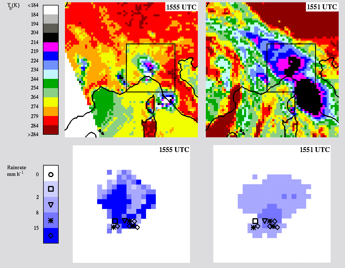
Figure 1: Comparison of rainfall estimates using the 1555 UTC SSM/I
overpass and the closest METEOSAT thermal infrared image (1551 UTC) for
the 27 September 1992 Genova flood event. Top panels are the SSM/I 85.5
GHz vertically polarized image (left) and the corresponding METEOSAT 11.5
micron image (right). Bottom-left panel shows the SSM/I-based rainfall
estimate using the rain-profile retrieval algorithm developed in Frascati-Rome-Tallahassee,
whereas the bottom-right panel shows the METEOSAT-based estimate using
a modified Negri-Adler-Wetzel technique. Bottom panels represent enlarged
views of the areas delimited by the black squares in the top panels. Raingage
measurements are superimposed as black symbols. The images are displayed
in Mercator projection. [Taken from V. Levizzani, F. Porc—, F.S. Marzano,
A. Mugnai, E.A. Smith, and F. Prodi: Investigating SSM/I Microwave Algorithm
to Calibrate METEOSAT Infrared Instantaneous Rainrate Estimates. In press
on Meteorological Applications.]
Back